Extract elevations from DEM
The code below uses the Toolbox SDK, which you can install with pip install toolbox-sdk.
Additional Python examples: using SDK, using Requests. If you prefer other programming language or need full API reference, check out Toolbox OpenAPI as well.
Docs
The extraction of elevations from DEM. Returns CSV with coordinates and altitude.
Inputs:
ZIP-compressed CSV - CSV table with coordinates of points. Delimiter should be comma. Corrdinates are floating values. File should not have spaces and should contain only latin symbols. How to prepare the file in QGIS.
Latitude - name of the Latitude column. Case-sensitive.
Longitude - name of the Lonitude column. Case-sensitive.
-
Output format:
CSV
ESRI Shapefile
MapInfo TAB
GeoJSON
GPKG
DXF
FlatGeobuf.
-
Elevation dataset - select one of the following:
Copernicus
ALOS - ALOS World 3D has resolution of 30 meters
MERITDEM
GEBCO - resolution is 15 sec (about 500 meters).
Outputs:
CSV file or ZIP-compressed file of other selected format with coordinates and elevation values for the points.
How to prepare data
To save a point layer as a CSV file with coordinates in QGIS, go to Layer –> Save as. In the Format field select “Comma separated values.
In the Layer options section select for the GEOMETRY field the option AS_XY. The resulting file will have longitude in the X column and latitude in Y column.
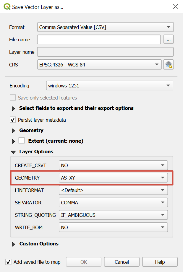
Exporting point layer as CSV
Try the tool in action
Click on the Demo button above the tool form. The fields are filled in with demo values.
Click on the Run button.